Back مقاطعة ويرت (فرجينيا الغربية) Arabic Wirt County, West Virginia BAR Уърт (окръг, Западна Вирджиния) Bulgarian ৱিট কাউন্টি, ৱেস্ট ভার্জিনিয়া BPY Wirt Gông (West Virginia) CDO Уэрт (гуо, Малхбузен Виргини) CE Wirt County CEB Wirt County, Gorllewin Virginia Welsh Wirt County German Kantono Wirt Esperanto
Wirt County | |
|---|---|
 The Wirt County Courthouse in Elizabeth | |
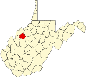
 Location within the U.S. state of West Virginia | |
 West Virginia's location within the U.S. | |
| Coordinates: 39°01′N 81°23′W / 39.02°N 81.38°W | |
| Country | |
| State | |
| Founded | January 19, 1848 |
| Named for | William Wirt |
| Seat | Elizabeth |
| Largest town | Elizabeth |
| Area | |
| • Total | 235 sq mi (610 km2) |
| • Land | 233 sq mi (600 km2) |
| • Water | 2.3 sq mi (6 km2) 1.0% |
| Population (2020) | |
| • Total | 5,194 |
| • Estimate (2021) | 5,063 |
| • Density | 22/sq mi (8.5/km2) |
| Time zone | UTC−5 (Eastern) |
| • Summer (DST) | UTC−4 (EDT) |
| Congressional district | 2nd |
| Website | www |
Wirt County is a county in the U.S. state of West Virginia. As of the 2020 census, the population was 5,194,[1] making it the least populous county in West Virginia. Its county seat is Elizabeth.[2] The county was created in 1848[3] by the Virginia General Assembly and named for U.S. Attorney General and presidential candidate William Wirt. The county is served by one high school, Wirt County High School.
Wirt County is part of the Parkersburg-Vienna, WV Metropolitan Statistical Area.
- ^ "State & County QuickFacts". United States Census Bureau. Retrieved August 14, 2022.
- ^ "Find a County". National Association of Counties. Retrieved June 7, 2011.
- ^ "Archived copy". Archived from the original on September 23, 2001. Retrieved February 4, 2013.
{{cite web}}: CS1 maint: archived copy as title (link)
© MMXXIII Rich X Search. We shall prevail. All rights reserved. Rich X Search
